
Knockbane [Lambay Island]
Good walks are even better shared.
Overview
Knockbane [Lambay Island]
Nestled in the shimmering waters of Dublin Bay, Knockbane stands as a subtle yet splendid Marilyn, offering hikers the chance to explore its volcanic terrain enveloped in rugged beauty. With an elevation of 100 meters, it might not be the tallest of peaks, but its charm lies in the combination of scenic views and unique geological features.
Geology
The foundation of Knockbane is primarily volcanic rock, specifically basalt, adding a touch of drama to the landscape. These geological formations are not just aesthetically pleasing but tell a tale of volcanic eruptions from millions of years ago. Keep your eyes peeled for the erosive patterns that nature has painted on the rocky surface.
Routes
The most popular route to the summit begins at the northern harbour. This coastal path is approximately 2.5 km long and takes about 1.5 hours to complete. It’s rated as moderate due to some rocky sections, but nothing too daunting — just enough to make that victory pint taste sweeter upon your return.
Summit Features
As you reach the summit, you’re greeted by a humble stone cairn that’s as charming as it is practical. It serves as a perfect backdrop for celebrating your triumph, or for capturing that 'I conquered Knockbane' selfie!
Terrain Type
Expect a mix of rocky outcrops and grassy slopes. A sturdy pair of boots will do wonders; your feet will thank you later.
Views
The views from Knockbane's summit are a true reward for your efforts. Glance towards Dublin Bay, and on clear days, you might even spot the Mourne Mountains peeking through the clouds. Spring and summer are the best seasons to witness this spectacle, as everything comes alive with colour.
Hazards
While the paths are generally safe, caution is key. The rocky paths can be slippery, especially after rain, so be sure to watch your footing. High tide can also limit access to certain areas, so check the tides before you go — no one wants to be marooned on an island, unless it's for a well-deserved holiday!
Access
Accessing Knockbane involves parking at the pier in Portrane, where you can hop onto a boat heading to the island. Public transport options are limited, making a personal boat your best bet.
Facilities
Once you set foot on Lambay Island, the nearest comforts are not on the island itself but must be found back in Portrane, where you’ll find quaint cafes and necessary toilet facilities.
History
The name Knockbane comes from the Irish term 'Cnoc Bán', which translates to 'white hill'. It hints at the light hues of the cliffs that contribute to the island’s allure. Lambay Island carries a rich historical narrative, having been a significant site through various eras, inhabited since prehistoric times.
In summary, whether you’re an avid hiker or just looking for a pleasant day out, Knockbane offers an delightful escape and an opportunity to connect with both nature and history. So pack a picnic, lace your boots, and get ready to explore a little slice of Irish beauty!
Explore routes near Knockbane [Lambay Island]
Public walks starting within 80 km of this hill. Nearby does not mean a route reaches the summit; check its map and access before setting out.
Route planning notes
These notes describe possible approaches, not verified navigable routes or permission to cross land. Check current paths, local access rules and conditions before setting out.
Coastal Path from the Harbour
A scenic route starting from the northern harbour, this trail winds its way along the coastline before ascending to Knockbane, offering stunning sea views.
Make a day of it, together
Find someone to share the walk with, or organise a day out along a route you like.
Hill facts and local notes
Classifications
Elevation
126m
413 ft
Prominence
126m
Coordinates
53.4928, -6.0179
O316510
OS Map
43
At the Summit
The summit is marked by a small stone cairn, providing a perfect photo opportunity at the highest point on the island. The views from up here will leave you grinning like a Cheshire cat.
Terrain & Geology
Lambay Island is primarily composed of volcanic rock, particularly basalt, which contributes to its rugged terrain and unique shapes. Its geological history is significant as it showcases volcanic activity from millions of years ago.
Views & Scenery
From the summit, see Dublin Bay, the Mourne Mountains in the distance, and the stunning coastline of Lambay Island itself.
History & Heritage
Name Origin
The name 'Knockbane' is derived from the Irish 'Cnoc Bán', meaning 'white hill', likely referring to the light-coloured cliffs.
Historical Significance
Lambay Island has a rich history, having been inhabited since prehistoric times and serving as a strategic location throughout various periods.
Getting There & Facilities
Check current local access restrictions, parking rules and transport timetables before travelling. These notes do not confirm public access to the summit.
Parking
Parking is available at the pier before boarding a boat to Lambay Island.
Public Transport
Limited public transport; best accessed by private boat or ferry.
Nearby Facilities
There are no facilities on the island, so bring your own snacks and drinks. The nearest cafes can be found in Portrane.
Safety Information
Known Hazards
- Watch for slippery rocks along the coastal paths and keep an eye on the tide, as some areas may become inaccessible during high tide.
General Safety Tips
- Check weather conditions before setting out
- Carry appropriate clothing and equipment
- Let someone know your planned route
- Take a map, compass, and GPS device
- Carry emergency supplies: food, water, first aid kit, torch
Hills
Some common questions about the hills answered
Are there group walks up Knockbane [Lambay Island]?
Many walkers use Walkmates to join or organise walks with others. You can check for group walks around Knockbane [Lambay Island] through the maps
Are there other walkers around Knockbane [Lambay Island]?
Activity varies by location and time, but Walkmates lets you see whether others have shared walks or shown interest in this area. Find other people through the walking friends search walking friends for Knockbane [Lambay Island] search or of course create your own walk for Knockbane [Lambay Island]
Can I organise a walk to Knockbane [Lambay Island]?
Yes. If there aren’t any walks listed already, you can create a walk and make it available for others to join.
If you're signed up to Walkmates, you can create a walk to Knockbane [Lambay Island].
How do I find a walk up this hill?
There are often multiple ways to walk this hill, depending on experience and route preference. Walkmates helps you explore walks and routes that others have shared.
Can I suggest a new route up Knockbane [Lambay Island]?
Yes. You can suggest or create routes to share with others. Walkmates focuses on the social side of walking, so routes are used to help people organise walks and explore areas together, rather than as detailed navigation tools or route libraries.
Other uses really appreciate knowledgeable walkers sharing their routes. Share your favourite route to Knockbane [Lambay Island] here
The is an error or something incorrect about this hill. How do I let you know?
We always strive to keep the information on Walkmates as accurate as possible. If you find an error, please let us know through the contact form and we'll aim to correct it as quickly as possible
Community Discussion
Comments
Location
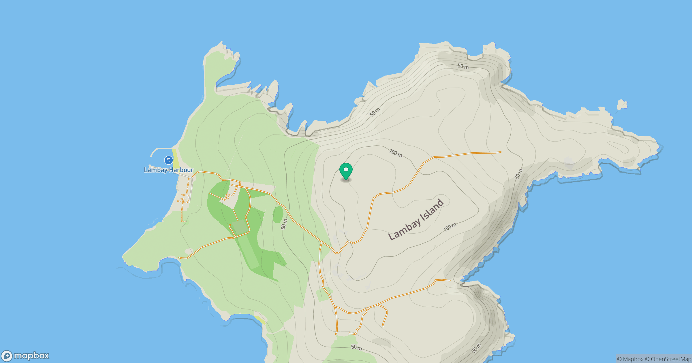
Grid reference: O316510
View on OpenStreetMapOpens a map in a new tab, centred on the hill.
Hills within 30 km
Straight-line distance, not a walking route or confirmation of access.
No comments yet. Be the first.